 Richard Smith doesn’t mind when the SituMap application he and his team developed at Texas A&M-Corpus Christi is compared to something out of a crime scene investigation TV show.
“The most common comment I get is, ‘Wow! It’s like on CSI. Don’t they already have that?’” said Smith, an assistant professor in the university’s science and engineering department.
He responds by saying, “Not really, but I’m glad you’re comparing it to CSI. That’s a hell of a compliment.”
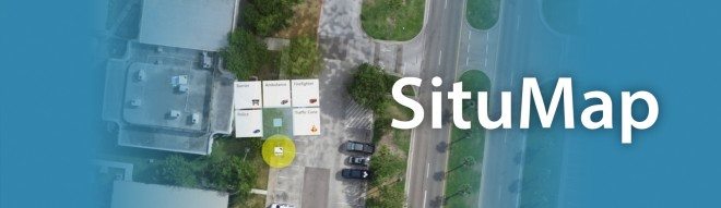
When paired with high-resolution imagery from an unmanned aerial system (UAS) and a coffee-tabled-sized Microsoft Surface Table, SituMap software provides emergency management decision-makers with a powerful tool that can help them make plans and provide direction during situations when time is of the essence.
“With SituMap, the idea is to reduce the barriers of entry for mapping,” Smith explained. “Do I want to draw on the hood of an SUV or draw on SituMap and share it?”
Because of SituMap, the days of using an outdated map on the wall or SUV hood could be nearing an end. The program enables emergency managers to quickly and clearly relay instructions to personnel in the field dealing with a disaster, accident, police situation or other emergency. They can add assets such a police cars, ambulances and fire trucks, then provide instructions on where they should go and what they should do.
“We can keep track of where things move because there’s a lot of construction going on on campus and a lot of temporary buildings,” Smith noted.
“For instance, the Wells Fargo bank didn’t exist on one image, but it’s there now, and police generally want to know where the banks are,” he said.
The app has been in development for more than a year, and Smith said their local police have been using it since last June.
“The chief’s hooked,” he said. “We know it’s good for public safety, for campus safety and police safety.”
Texas A&M-Corpus Christi is one of six UAS test sites in the U.S. designated by the Federal Aviation Administration. Under the university’s certificate of authorization, a senseFly eBee unmanned aerial vehicle (UAV) is flown over the campus every two months to gather data. Assistant professor Michael Starek directs the UAV data collection in collaboration with Smith.
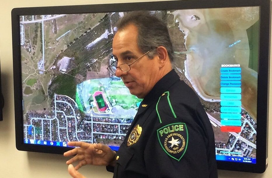
“We collect high-resolution, high accuracy data because we run proper survey controls,” Smith said. “Then we integrate that into SituMap. The police chief gets it, we have it, and that allows police to increase their awareness for public safety.”
A video of Smith demonstrating the program shows the level of up-to-date detail that managers in an emergency operations center can receive about an area in which an incident is occurring. The Surface Table is a touch screen that can accept 50 simultaneous touch inputs which enables multiple users to draw and write on it.
“It’s a shared resource; it’s a collaborative resource,” Smith said. “The UAV imagery is the focal point that allows them to talk about up-to-date information. They can relate to it because it’s no longer an abstract drawing.”
One of Smith’s primary goals was to make SituMap easy to learn and use, which meant finding ways to take the fear out of new and unfamiliar technology. He drew inspiration from the Matchbox cars he played with as a child, World War II movies and computer games.
To make it easy to add an emergency vehicle to a developing situation, a toy police car, ambulance or fire truck equipped with a data chip is placed on the Surface Table which instantly records its location. It not only makes the task simple, it’s also part of SituMap’s appeal.
“How can I make it inviting to map? How do I get it out of the hands of the trained few who know how to map?” Smith asked. “Let’s just go back to playing with Matchbox cars.”
And, he noted, “My most entertaining research expense to date was turning in a receipt for Matchbox cars from Toys R Us.”
Smith also drew inspiration from old black-and-white World War II movies showing admirals planning naval strategy.
“They had the big maps and pushed around little aircraft carriers with sticks,” he said. “I was thinking a digital war table like that would be cool. It was a way to combine the physical interaction with the digital interaction.”
An avid computer gamer, Smith also incorporated some of his gaming knowledge into SituMap.
“It gets people interested and engaged,” he explained. “Once they’re not afraid to touch the map, then you can have a conversation around it, and that’s what’s exciting for me.”
The next challenge is for Smith and his research team is to discover how quickly they can collect data from the UAV, process it and load it into SituMap to provide emergency managers with the most accurate and up-to-date imagery.
“Police and fire personnel typically want a decent answer now rather than the best answer later,” he said. “With 15 minutes of flying and 10 minutes of processing, is that going to fit their needs? I think the answer’s going to be yes, but we definitely want to investigate further.”
Smith believes that SituMap could be used in other areas, such as the oil and gas industry. He leaves the impression that no matter which direction his research leads, it will be enjoyable.
“It’s been fun to play with, I tell you,” he said.
Retrieved from UAS magazine article Powerful UAS app draws inspiration from movies, toys, games
March 17th 2015