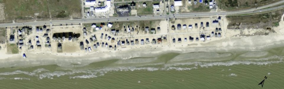
Jamaica Beach

Overview:
Jamaica Beach is located in Brazoria County approximately mid-way between Galveston and San Luis Pass. The eastern end of Jamaica Beach lies at the CBRA boundary which stretches over 2 miles toward the east. The landward limit of this short, just over approximately 4,000-ft long segment of beach has been historically composed of a narrow row of intermittent low coppice mounds that have been repeatedly destroyed or compromised during frequent storms. More recently higher elevation dunes have been established along the backshore. Jamaica Beach fronts a small private community of residences located directly along the Gulf beach. Historically various alternatives such as rubble and sand filled tubes have been placed along this section of beach to protect backshore infrastructure and limit inundation of the backshore infrastructure, particularly during storms.
With regard to beach erosion and shoreline recession in recent years, Jamaica Beach is located along a relatively stable segment of Galveston Island (City of Galveston 2012, BEG 2011, Morton 1985). Of greater concern is the lack of sustainable dunes along this stretch of coast which allows for inundation of the backshore infrastructure of the City of Jamaica Beach. Therefore, projects at Jamaica Beach have focused on dune restoration and reinforcement rather than extensive beach nourishment.
Several studies have addressed changes in the beach, dunes and shoreline at Jamaica Beach. Erosion response alternatives were investigated during CEPRA Cycle 2-Cycle 5 including studies of the coastal processes acting at San Luis Pass. A dune restoration project was completed in August of 2006 along a 2,840-ft section of the beach (CEPRA 1214). The dune restoration consisted of the placement of approximately 26,100 cu yd of sand between STA 386+75 and STA 417+20 (BMMP 2010). Hurricane Ike (September 2008) caused extensive damage to the duneline at Jamaica Beach. TGLO planning toward future dune restoration continues as of this reporting.
The 2013 CBI study established a baseline from which to determine the long-term stability of Jamaica Beach and potential need for beach nourishment in the future by defining a Target Width and Action Width as well as the rate of shoreline change based on beach profile and shoreline position survey data. The 2014 and 2015 surveys have provided an annual assessment of change in morphology, including dune stability, as well as the rate of shoreline position change and erosion toward support of proactive beach management.
Location:
View CHRGIS sites in a larger map